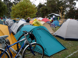
I’ve found a photo of a kangaroo or two, taken south-west of Kalgoorlie a couple of years ago but unfortunately no koalas are in my albums. (The cyclists did have heads, but I've edited them out to maintain anonymity even though it looks a bit queer.)
It was great to be around kindred spirits and have a cup of tea from their kettles – they were very kindly - often I’d follow the cuppa with a bit of a kip when I got to the campsite.
 My knobbly knees suffered a fair bit, and exhaustion kicked in each evening. But on this particular day there was a bit of a kerfuffle when the crazy emus kept pinching ketchup sandwiches from the kindly kids. The kangaroos weren’t much better and of course the kids treated them with kid gloves because they were in awe of them and were afraid they’d be kicked in the kidneys if they weren’t compliant.
 Honestly, you almost need to use karate or kick boxing to keep the creatures away they’re so keen to collect your food. But if we did that, they’d keel over and that’d be bad for your karma and the cops might hold a kangaroo court wearing kaftans (this is crazy!)
 Many years ago, I saw a kangaroo on the beach hopping over the kelp (true dinks!) and was surprised when it swam across a creek. Even weirder was watching kookaburras chomping strawberries.
 Simple pleasures, happy memories - sometimes I think I've lived better than a king.
Thankyou to Mrs Nesbitt and her kindly team for hosting ABC Wednesday. Click to see fabulous variations on the theme from participants from around the world.
.


